


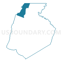
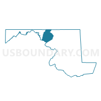
Frederick Precinct 10-001, Frederick County, Maryland
About
Outline

Summary
| Unique Area Identifier | 592364 |
| Name | Frederick Precinct 10-001 |
| County | Frederick County |
| State | Maryland |
| Area (square miles) | 29.14 |
| Land Area (square miles) | 29.09 |
| Water Area (square miles) | 0.05 |
| % of Land Area | 99.82 |
| % of Water Area | 0.18 |
| Latitude of the Internal Point | 39.66233090 |
| Longtitude of the Internal Point | -77.47811840 |
Maps

Graphs
Select a template below for downloading or customizing gragh for Frederick Precinct 10-001, Frederick County, Maryland


Neighbors
Neighoring Voting District (by Name) Neighboring Voting District on the Map
- Frederick Precinct 05-001, Frederick County, MD
- Frederick Precinct 06-001, Frederick County, MD
- Frederick Precinct 15-001, Frederick County, MD
- Frederick Precinct 15-002, Frederick County, MD
- LIBERTY TWP Voting District, Adams County, PA
- Washington Precinct 07-001, Washington County, MD
- Washington Precinct 14-002, Washington County, MD
- WASHINGTON TWP VTD 01, Franklin County, PA
Top 10 Neighboring County Subdivision (by Population) Neighboring County Subdivision on the Map
- Washington township, Franklin County, PA (14,009)
- District 15, Thurmont, Frederick County, MD (8,943)
- District 5, Emmitsburg, Frederick County, MD (6,674)
- District 7, Smithsburg, Washington County, MD (6,343)
- District 14, Ringgold, Washington County, MD (2,752)
- District 10, Hauvers, Frederick County, MD (2,339)
- District 6, Catoctin, Frederick County, MD (2,107)
- Liberty township, Adams County, PA (1,237)
Top 10 Neighboring Place (by Population) Neighboring Place on the Map
Top 10 Neighboring Unified School District (by Population) Neighboring Unified School District on the Map
- Frederick County Public Schools, MD (233,385)
- Washington County Public Schools, MD (147,430)
- Waynesboro Area School District, PA (32,339)
- Fairfield Area School District, PA (7,992)
Top 10 Neighboring State Legislative District Lower Chamber (by Population) Neighboring State Legislative District Lower Chamber on the Map
- State Legislative Subdistrict 4A, MD (81,354)
- State House District 90, PA (70,210)
- State House District 91, PA (66,509)
- State Legislative Subdistrict 2A, MD (44,505)
Top 10 Neighboring State Legislative District Upper Chamber (by Population) Neighboring State Legislative District Upper Chamber on the Map
- State Senate District 33, PA (280,954)
- State Senate District 2, MD (131,810)
- State Senate District 4, MD (125,297)
Top 10 Neighboring 111th Congressional District (by Population) Neighboring 111th Congressional District on the Map
- Congressional District 6, MD (738,943)
- Congressional District 19, PA (728,630)
- Congressional District 9, PA (666,810)
Top 10 Neighboring Census Tract (by Population) Neighboring Census Tract on the Map
- Census Tract 316, Adams County, PA (6,887)
- Census Tract 113.01, Washington County, MD (5,195)
- Census Tract 125.02, Franklin County, PA (3,732)
- Census Tract 7528.02, Frederick County, MD (3,550)
- Census Tract 7529, Frederick County, MD (3,066)
- Census Tract 7528.01, Frederick County, MD (2,214)
- Census Tract 101, Washington County, MD (1,388)
Top 10 Neighboring 5-Digit ZIP Code Tabulation Area (by Population) Neighboring 5-Digit ZIP Code Tabulation Area on the Map
- 21788, MD (11,622)
- 21783, MD (9,130)
- 17320, PA (7,823)
- 21727, MD (5,850)
- 21773, MD (5,460)
- 21780, MD (1,625)
- 21719, MD (1,548)
- 17214, PA (1,089)